Processing...

The ancient city of Stratonica

Coordinates 775 people viewed ID: 4521

Access Details

Bumpy road %0
Road distance 40K
Arrival time 40m
Taxi Fare
Live Weather & Visibility Telemetry
Live & Instant Update • Checked: 22:15
Horizontal Visibility
Clear & Excellent Visibility (25 km)
Current Temperature
22°C
Cloud Cover
10%
Wind Speed
5 km/h

Description

Scan QR QR code
The ancient city of Stratonica, included in the UNESCO Temporary World Heritage List since 2015. The ancient city, which was a vital area since 1500 BC, that is, the Young Bronze Age, became one of the most important cities of the Karia states. The city, whose population has begun to decline since the early Byzantine period, was used as a permanent settlement during the 14th and 15th centuries and the principality period. The city limits can be well distinguished by the walls which are about 3600 meters long. In the city, which was used as a settlement in the Hellenistic and Roman periods, an impressive city layout and sewage system were developed. Visitors to this ancient city have the opportunity to see the architectural features of different times such as the Roman, Ottoman and Emirati periods along with the ancient period.

Location: Mugla

Get directions

Nearby places & attractions
How far is it? Places in your area Search within range km

Regions
Restaurants
Hotels
Villas
Apartments
Cars
Telecom
The calculation accuracy of the distance and estimated arrival time is approximately 90%.
💬 Was this information helpful and accurate?

Comments

No comments has been added yet
Osmanle
Osmanle
Pro
🏆 Founding Expert
📍 Added 3937 tourist places
🏆 Osmanle Experts in Turkey

Do you know tourist places or routes? Share your experiences and earn a verified expert badge.

Recently Viewed Places

Sakarya
The ancient city of Stratonica
Osmanle 🏆 Founding Expert
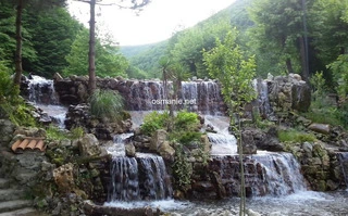
Ma'shouqia waterfalls, more than 20 waterfalls, flow from Mount Kartepe, and the views are wonderful in the atmosphere of this picturesque place. There is a large group of wonderful restaurants and hotels, and most services are available.
193.1 Thousand people viewed
%10
32K
41m
Sakarya
Doan Chai Waterfall
Osmanle 🏆 Founding Expert
Doan Chai Waterfall, is a address for daily travelers and campers. Its height is 600 meters. There is also a trekking path for those wishing to hike in the nature at the waterfall, the waters of which flow down on three levels. It was declared a nature park in 2013 by the Ministry of Forestry and Water Affairs. The waterfall, which will impress you with its ...
1.8 Thousand people viewed
%0
30K
45m
Plan your trip & save your favorite spots Create Free Account
Copyright © 2026 osmanle.net All rights reserved.
Non-logged user
Hello wave
Welcome! Sign in or register
Planning & Discovery
Travel Services
Community & Guides
App Icon
Osmanle App
Faster & easier guide for tourism in Turkey
Install on iPhone

Tap the Share button at the bottom of Safari, then select "Add to Home Screen" ➕

🚖

Estimated Taxi Fare Calculator 🚕

Destination (Arrival Point):
...
Departing from: ...
Estimated Distance: 0 km
Estimated Time: ~ 0 mins
Estimated Taximeter Fare:
0 ₺
($ 0.00)
💡 Information: Fares are taximeter estimates based on official rates and may vary with traffic, excluding electronic bridge/highway tolls (HGS).