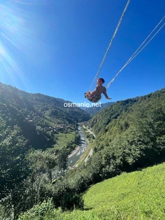
It is in the famous Camlihemsin district of Rize for its wooden houses made of pine, hornbeam and chestnut trees. Wonderful nature view, with unforgettable memories in nature with your loved ones.
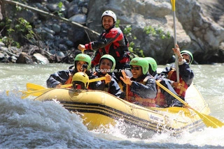
The Vertina Current was formed by the merging of streams on the slopes of the Kachkar Mountains facing the Black Sea. It is among the first places preferred by nature lovers. It is 57 kilometers long. The Vertina Stream runs through tea gardens and is decorated with arch bridges, and has paths suitable for rafting. It is suitable for river sports throughout ...
Pokot plateau is located at an altitude of 2020. A very popular plateau in terms of tourism for its unspoilt nature and stunning scenery. It is estimated that the first settlement on the Pokot plateau, which means valley of winds in Armenian, occurred about 200 years ago. Pokot Plateau, one of the most beautiful Ayder plateaus, gets filled with local and for...
Lake Ambarley is a lake located at an altitude of 2,995 meters. It has four other small lakes around it, which is the last point that can be reached by car. It is the place where different sports clubs interested in natural sports trips and camping every year; It has a great view.
The live village of Chana attracts the attention of campers and those who want to spend time in nature. You can do everything naturally, such as gathering firewood, carrying water, making a fire, and digging holes for toilet needs, in the most natural way. It is possible to take part in various tours to see and explore the natural beauty of Findikli and its ...
The Golasina plateau is located 2,230 meters above sea level. The Golasina plateau, with a mysterious appearance with its original and local homes, houses an average of 100 families. It hosts colorful plateau festivals every summer.
Qalar Plain, it is one of the flat areas, it is a quieter spot compared to the Ayder plateau, you reach the Qalar Plain in about half an hour from the Ayder plateau, you can also enjoy the wonderful views on the road. There are very suitable areas for camping. The area, at 1,600 meters, is very cold in almost every season.
The Vertina River, one of the symbols of Ayder and even the Black Sea, is a mythical stream that has been the subject of films. One of the largest rivers in the eastern Black Sea basin, with an area of 1177.03 km2, is approximately 58 km long. It flows into the Black Sea, as a stream consisting of a mixture of streams flowing from the slopes of the Kachkar M...
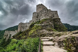
Ibala Castle as one of the historical places and structures. It is estimated that the castle, which resembles Castle Zell in terms of structure and construction and means high as a name, was built in the same period, that is, between the fourteenth and fifteenth centuries. It is referred to in some sources as Pharos Castle. The castle is located on steep slo...
Chenyova Bridge is a historic arched bridge built in 1696. Built with one eye according to the geography of the Black Sea, it is 40 meters long and 20 meters high. It is one of the famous buildings amongst local and foreign tourists today. In the middle of the picturesque nature.
The brides dress cascade, so named because of its white water flowing like tulle and veil. It is a natural wonder that dazzles those who see it with its wonderful sight. With a steep flow of 1500 meters, only the last part of the waterfall, which is located at an altitude of 1320 meters, can be seen due to dense fog. The highest waterfall in Turkey has the d...
The Chat Valley, one of the most precious beauty, is a heaven-like valley with its rich vegetation, endemic flower species, fruit trees, rhododendron (kumar) trees, spruce trees and trumpet trees. Due to these features, the valley meticulously protected by the locals, is a destination that attracts great interest from tourists today. The village is decorated...
The waterfall, which can be reached on foot from a one kilometer long road and empties from a height of 35 meters, where there are other waterfalls near it, as a natural park named Akyamach Falls. An area of 50 hectares of land has been prepared, a one-kilometer road has been built up to the waterfall. A visitor restaurant is built near the waterfall, which ...
Hosier plateau where you will feel as if you are above the clouds. You can see Avosur, the valleys of Kafron, the eastern coast of the Black Sea, the hills of Hazzendak and Boukot Sal, that is, everywhere at an altitude of 4000 meters, they are located on the mountains that carry the left side of Ayder Plateau.
Being the most populous plateau in the Ardeshyn, which consists of 300 families on average, it is very popular for its plateau festivals which take place in the second week of August. Siirt plateau, facing the vast Black Sea and the Kachkar Mountains, has a great view. Because of this feature, it is an area that is frequently visited by domestic and foreign ...
Zell Castle attracts many local and foreign tourists in terms of tourism, it is located on the western slopes of the Vertina Stream at an altitude of 750 meters from the sea. It is estimated that it was built during the Trabzon Empire in the 14th century, to ensure the safety of an important caravan route from the Middle Ages. The castle, which was occupied ...
Samestal Plateau, is one of the highest Eder plateaus at an altitude of 2,450 meters, and it is one of the typical plateaus of the Black Sea. The Samstal Plateau reflects the local architecture of the eastern Black Sea in the best way with its raft houses built with large stone blocks. It hosts an average of 200 stone houses, in the plateau where a coffee sh...
The bridge is built, with round arches and single eyes. It was built by locals in the latter half of the 18th century. The arch and the fence of the bridge were constructed of cut stone, while the other parts were constructed from rubble stone. The bridge is 44 meters long, 10 meters high and 2.7 meters wide.
Ayder Plateau, like a corner of Heaven, with its forests made of fir and beech trees, lush vegetation and original Hamshen homes, is a mythical plateau with its healing spicy spring and delicious honey. It is estimated that the first settlement in Ayder Plateau dates back to the thirteenth century; The roots of the spa on the plateau are known to date back t...
Kafron plateau is located at an altitude of 2,240 meters at the foot of the Kachkar Mountains, and it consists of two separate areas, the Ashagi Kafron plateau and the Yukari-Kafron plateau. Kafron, one of the plateaus where plateau tourism is most intense, hosts 240 families. According to geologists, the Kafron Plateau, which was a valley covered with glaci...
Vasha Plateau, where residents of neighboring villages continue their livestock activities, at an altitude of 2,643 meters above sea level. The plateau has a wonderful view, with a wonderful nature where nature and sports lovers can practice natural sports such as trekking and camping.
It has an impressive architectural texture. The inscription on the stone bridge contains explanations about the past. The bridge was built in 1898 by Sheikh Muhammad Siddik, who signed the important architectural structures of the city. It is 17 meters long, has one eye and is 11 meters high from the water in the middle. meters, smooth cut stones were used i...
Manisa City Forest, has become a breathing place for Manisa residents since the day it was first opened in 2007. Decorated with artificial ponds; 1.5 km of bicycle path, 5 km of walking path, 1650 m2 of transport roads and walkway covered with natural stone, 240 m2 of area can be covered, 3 decorative fountains with pond view, 1 watermill among the icons, 20...
Located next to the sugar factory, is the migration route of the pearl molts that live in Lake Van, this is where they go from the soda water of Lake Van to the freshwater stream to spawn, the sight of fish trying to lay eggs in the Daily Stream, offers a visual feast, as they swim Opposite the water, they look like they are jumping and dancing, if you want ...
The clock tower was built by the first mayor of Mugla, Haji Kadi Suleyman Effendi, in 1895, by a Greek engineer. One of the most important architectural works that the Greeks who lived in Mugla dedicated to the city is an important reason to see the clock tower. The tower is built on a 5-storey square plan and narrows upwards. The inscription, which includes...
Tokatli Canyon provides a wonderful natural environment for both hikers and families with children. Fun place outside the city center completely away from the noise. The upper parts of the valley have a spacious plain for tents. You can camp anywhere for free. There is a glazed balcony where you can view the valley from a birds eye view. A wooden staircase l...
Didi Korkut Park is located on a spacious area of 70 thousand square meters that can respond to all kinds of social activities. There are many points of activity in the park, from picnic areas, childrens playgrounds, cafes and volleyball courts, the park has a rich vegetarian presence and lush green areas!
Kapikaya Valley, the valley was formed by tectonic depressions and streams, is 20 kilometers long, 7250 meters of which have been opened for tourism, promises a scenic natural beauty to its visitors. Frequently visited by mountain climbers, hikers and photography enthusiasts, the valley is connected by a 16-meter-high bridge, after passing through this bridg...
Chakirgul Mountain, as a result of studies conducted by the Ministry in 2005, has been registered as a winter sports tourism center, and it is planned to build 7 mechanical facilities and 11 ski tracks in this tourist center.
Topamzja Plateau, located at an altitude of 2,640 meters from the sea, is a settlement where the Laz, continue their activities such as raising animals in the summer. In this pristine plateau, although there are no services like electricity, there are only 20-25 families in the plateau. The plateau, which is often visited by mountain sports people and nature...